


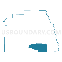
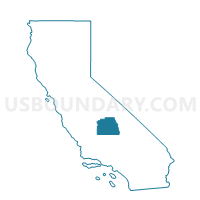
Voting District 55455, Tulare County, California
About
Outline

Summary
| Unique Area Identifier | 545314 |
| Name | Voting District 55455 |
| County | Tulare County |
| State | California |
| Area (square miles) | 293.83 |
| Land Area (square miles) | 293.83 |
| Water Area (square miles) | 0.00 |
| % of Land Area | 100.00 |
| % of Water Area | 0.00 |
| Latitude of the Internal Point | 35.89527240 |
| Longtitude of the Internal Point | -118.54698990 |
Maps

Graphs
Select a template below for downloading or customizing gragh for Voting District 55455, Tulare County, California


Neighbors
Neighoring Voting District (by Name) Neighboring Voting District on the Map
- Voting District 10000, Kern County, CA
- Voting District 10005, Kern County, CA
- Voting District 10010, Kern County, CA
- Voting District 55275, Tulare County, CA
- Voting District 55290, Tulare County, CA
- Voting District 55435, Tulare County, CA
- Voting District 55450, Tulare County, CA
- Voting District 55525, Tulare County, CA
- Voting District 55540, Tulare County, CA
- Voting District 55550, Tulare County, CA
Top 10 Neighboring County Subdivision (by Population) Neighboring County Subdivision on the Map
Top 10 Neighboring Place (by Population) Neighboring Place on the Map
Top 10 Neighboring Elementary School District (by Population) Neighboring Elementary School District on the Map
- Kernville Union Elementary School District, CA (11,432)
- Terra Bella Union Elementary School District, CA (5,795)
- South Fork Union Elementary School District, CA (3,680)
- Ducor Union Elementary School District, CA (1,276)
- Linns Valley-Poso Flat Union School District, CA (612)
- Hot Springs Elementary School District, CA (317)
Top 10 Neighboring Secondary School District (by Population) Neighboring Secondary School District on the Map
- Kern Union High School District, CA (596,351)
- Porterville Unified (9-12) School District, CA (47,072)